FLYING UNDER VISUAL FLIGHT RULES – VFR
It requires a set of practical skills to ensure safe and effective navigation and operation of the aircraft. Here are some key practical skills needed for VFR flying:
- Aircraft Control: Mastering the fundamental skills of controlling the aircraft, including straight and level flight, climbs, descents, turns, and coordinated maneuvers.
- Navigation: Navigating using visual references, landmarks, and aeronautical charts. This involves understanding how to interpret charts, use navigation instruments, and maintain situational awareness.
- Pilotage: Navigating by visual reference to landmarks on the ground. Pilots must be able to identify checkpoints and follow planned routes using ground features.
- Dead Reckoning: Estimating the aircraft’s position based on a previously known position, course, time, and speed. Dead reckoning is crucial for maintaining accurate navigation in the absence of visual references.
- Radio Communication: Effectively using the aircraft’s radio communication system to communicate with air traffic control (ATC) and other pilots. This includes understanding standard phraseology and procedures.
- Weather Assessment: Evaluating current and forecasted weather conditions to make informed decisions about whether it’s safe to fly. This includes recognizing weather patterns and understanding the impact of weather on the aircraft.
- Traffic Awareness: Maintaining awareness of other air traffic in the vicinity. This involves scanning the airspace for other aircraft and understanding right-of-way rules and collision avoidance procedures.
- Emergency Procedures: Being proficient in emergency procedures, including engine failures, equipment malfunctions, and other unexpected situations. This includes practicing emergency landings and other critical maneuvers.
- Aircraft Systems: Understanding and operating the essential systems of the aircraft, including engine, fuel, electrical, and avionics systems.
- Regulatory Compliance: Adhering to aviation regulations and procedures, including airspace rules, air traffic control instructions, and other legal requirements.
- Situational Awareness: Maintaining a constant awareness of the aircraft’s position, altitude, heading, and surroundings. This involves monitoring instruments, navigation equipment, and external references.
- Decision-Making: Making sound decisions based on available information and the current situation. This includes assessing risks and choosing appropriate courses of action.
- Communication with Passengers: If flying with passengers, being able to communicate effectively and provide reassurance, especially during takeoff, landing, or turbulence.
These skills are typically acquired through a combination of flight training, ground school, and practical experience. Continuing education and proficiency maintenance are crucial for VFR pilots to ensure safe and competent flying.
ENR 1.2 VISUAL FLIGHT RULES
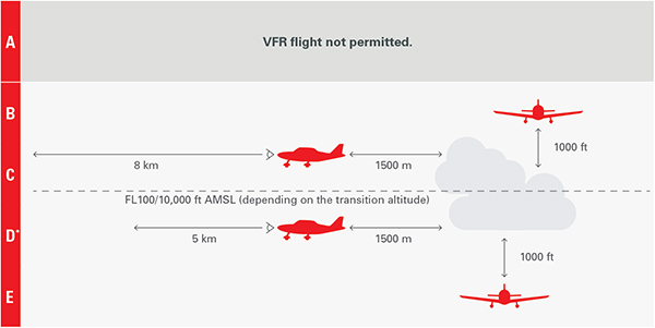
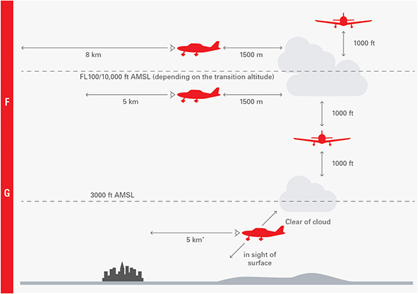
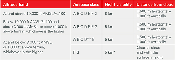
1. Except when operating as a special VFR flight, VFR flights shall be conducted so that the aircraft is flown in conditions of visibility and distance from clouds equal to or greater than those specified here after.
2. Except when a clearance is obtained from an air traffic control unit, VFR flights shall not take off or land at an aerodrome within a control zone, or enter the aerodrome traffic zone or traffic pattern:
a. when the ceiling is less than 450 M (1 500 FT); or
b. when the ground visibility is less than 5 KM.
2.1 VFR flights to be operated within a control zone established at an aerodrome serving international flights and in specified portions of the associated terminal control area shall:
a. have two-way radio communication;
b. obtain clearance from the appropriate air traffic control unit ; and
c. report positions, as required.
Note: The phrase “specified portions of the associated terminal control area” is intended to signify at least those portions of the TMA used by international IFR flights in association with approach, holding departure and noise abatement procedures.
3. VFR flights between sunset and sunrise, or such other the period between sunset and sunrise as may be prescribed by the appropriate ATS authority, shall be operated in accordance with the conditions prescribed by such authority.
4. Unless authorized by the appropriate ATS authority, VFR flights shall not be operated:
a. at or above FL 200;
b. during night period;
c. at transonic and supersonic speeds.
Note: Night is the period between 30 minutes after sunset to 30 minutes before sunrise.
5. Except when necessary for take-off or landing, or except by permission from the appropriate authority, a VFR flight shall not be flown:
a. over the congested areas of cities, towns or settlements or over an open-air assembly of persons at a height less than 300M (1000FT), above the highest obstacle within a radius of 600M (2000FT) from the aircraft;
b. elsewhere than as specified in 5 a), at a height less than 150M (500FT) above the ground or water.
SEMI-CIRCULAR RULE:
The semi-circular rule defines the altitude/flight level usable parity according to the magnetic route. It is applied from 3000 ft AGL, both in VFR and IFR and off airways (which have their specific parity).
In Lebanon, the semi-circular rule to be applied follows the standard East/West declination:
- “East” Magnetic route (000° < 179°): ODD altitude/flight level
- “West” Magnetic route (180° < 359°): EVEN altitude/flight level
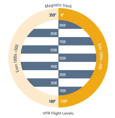
The airways (AWY), both in the lower airspace and in the upper airspace, have a published parity. In Lebanon, the majority of airways have a published parity that follows the standard North/South declination.
ALTIMETER SETTING:
The altimeter setting procedures applied in Lebanon include:
- Transition Altitude (TA): 13.000 ft
- Transition Level (TRL) This is the first IFR flight level at least 1000 ft above transition altitude, in Lebanon it is set at FL 150
- Transition layer (airspace between the transition altitude and the transition level) of a thickness strictly greater than 1000 ft, in Lebanon it is 2.000 ft
- Local QNH setting (rounded down to the nearest integer hPa) below the transition altitude (TA).
- Standard setting (1013,2 hPa) above transition level (TRL) – Flight level setting
- In the transition layer (between the TA and the TRL) no level flight, standard setting during climb and local QNH setting during descent.
- Local QFE setting possible only during approach or in the aerodrome circuit – Height setting.
- IVAO Reference
- Lebanon eAIP: LB-ENR-1.2-en-GB
FLYING UNDER INSTRUMENT FLIGHT RULES – IFR
The following is required:
- All the knowledge required to fly VFR: Understanding basic VFR principles, including airspace, weather, and navigation, forms the foundation for IFR flying.
- Flight Instruments & Navigation Equipment: Comprehensive knowledge of aircraft instruments and navigation equipment is essential for interpreting and using the information necessary for instrument flight.
- Chart Reading & IFR Procedures: Proficiency in reading aviation charts and understanding IFR procedures ensures precise navigation and adherence to air traffic control instructions.
- IFR Flight Planning and Flight Plan Filing: The ability to plan IFR routes, considering airways, waypoints, and alternate airports, and filing flight plans is crucial for organized and controlled IFR operations.
- VOR / NDB Navigation: Mastering VOR and NDB navigation techniques is essential for accurate course tracking and navigation along IFR routes.
- IFR Departure Procedure: Knowledge of IFR departure procedures ensures a smooth transition from the airport environment to the en route phase of flight.
- En Route Navigation: Effective navigation during the en route phase involves continuous monitoring of the aircraft’s position and adherence to assigned routes.
- IFR Arrival Procedure: Understanding IFR arrival procedures is crucial for a safe and orderly transition from the en route phase to the approach and landing.
- Holding Over a VOR: The ability to enter and maintain a holding pattern over a VOR aids in managing traffic flow and ensuring safe separation.
- Holding Over a FIX: Proficiency in holding over a fix provides flexibility in air traffic control and helps manage traffic in busy airspace.
- ILS Approach: Knowledge and skill in executing ILS (Instrument Landing System) approaches enable precise guidance during the final stages of an instrument approach.
- Non-Precision Approach: Understanding and executing non-precision approaches, such as VOR or GPS approaches, is crucial for IFR flights in locations without precision approach systems.
- Missed Approach: Being familiar with missed approach procedures is essential for handling situations where a safe landing cannot be completed.
- Circling Approach: Proficiency in circling approaches is necessary for safely aligning the aircraft with the runway after completing a non-precision approach.
- Continuous Monitoring: Pilots must maintain constant vigilance, cross-checking instruments and navigating equipment to ensure the aircraft’s safe operation throughout the IFR flight.
INSTRUMENT FLIGHT RULES
While an instrument-rated pilot is trained and equipped to handle a broader range of weather conditions compared to a VFR (Visual Flight Rules) pilot, there are still limitations to the weather conditions in which an instrument-rated pilot can safely operate. The specific weather conditions that a pilot can fly into depend on various factors, including the pilot’s experience, the capabilities of the aircraft, and applicable regulations. Here are some considerations:
- Minimum Equipment Requirements: Aircraft must meet certain equipment requirements to operate in instrument meteorological conditions (IMC). This includes having the necessary instruments and avionics for navigation and communication.
- Personal Minimums: Pilots often establish personal minimums, which are self-imposed limitations based on their comfort level and proficiency. These personal minimums may include factors such as visibility, cloud cover, and wind conditions.
- Regulatory Requirements: Pilots are required to comply with regulatory weather minimums. These minimums vary depending on the type of airspace, phase of flight, and the specific approach being conducted.
- Aircraft Performance: The aircraft’s performance capabilities, including its avionics and de-icing equipment, can influence the weather conditions in which a pilot can safely operate.
- Training and Experience: The pilot’s training and experience play a crucial role. An instrument-rated pilot with more experience and proficiency in handling challenging weather conditions may be able to operate in conditions that a less experienced pilot might avoid.
- Decision-Making Skills: Sound decision-making skills are essential. Pilots should be able to assess weather reports, forecasts, and current conditions to make informed decisions about the safety of the flight.
- Operational Considerations: Some weather conditions, such as severe turbulence, thunderstorms, or icing, may pose significant operational challenges. Pilots may choose to avoid or divert around such conditions.
- Fuel Reserves: Pilots need to consider fuel reserves when planning a flight. Adverse weather conditions may lead to longer flight times or necessitate diversions, and pilots must ensure they have adequate fuel for such situations.
While instrument-rated pilots have the training and equipment to navigate through a wide range of weather conditions, it is crucial for them to exercise good judgment and adhere to safety regulations. Ultimately, the decision to fly in specific weather conditions should be based on a thorough assessment of the risks and the pilot’s ability to safely conduct the flight.
SEMI-CIRCULAR RULE:
The semi-circular rule defines the altitude/flight level usable parity according to the magnetic route. It is applied from 3000 ft AGL, both in VFR and IFR and off airways (which have their specific parity).
In Lebanon, the semi-circular rule to be applied follows the standard East/West declination:
- “East” Magnetic route (000° < 179°): ODD altitude/flight level
- “West” Magnetic route (180° < 359°): EVEN altitude/flight level
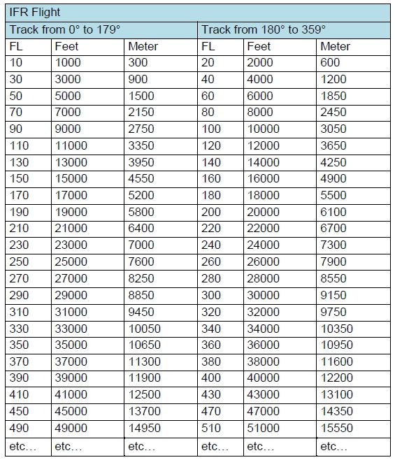
Source: ivao.aero
The airways (AWY), both in the lower airspace and in the upper airspace, have a published parity. In Lebanon, the majority of airways have a published parity that follows the standard North/South declination.
ALTIMETER SETTING:
The altimeter setting procedures applied in Lebanon include:
- Transition Altitude (TA): 13.000 ft
- Transition Level (TRL) This is the first IFR flight level at least 1000 ft above transition altitude, in Lebanon it is set at FL 150
- Transition layer (airspace between the transition altitude and the transition level) of a thickness strictly greater than 1000 ft, in Lebanon it is 2.000 ft
- Local QNH setting (rounded down to the nearest integer hPa) below the transition altitude (TA).
- Standard setting (1013,2 hPa) above transition level (TRL) – Flight level setting
- In the transition layer (between the TA and the TRL) no level flight, standard setting during climb and local QNH setting during descent.
- Local QFE setting possible only during approach or in the aerodrome circuit – Height setting.
- IVAO Reference
- Lebanon eAIP: LB-ENR-1.3-en-GB


